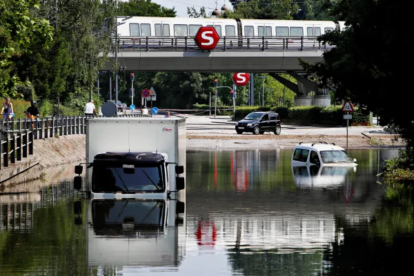
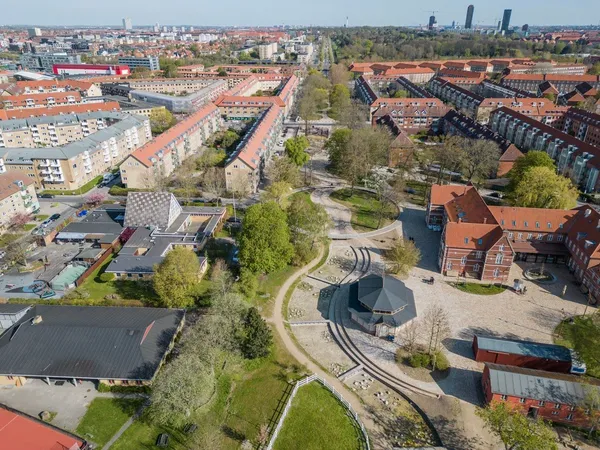
July 2011 Copenhagen's cloudburst, Martin Lehmann. Polfoto via AP.
As many cities worldwide grapple with the escalating impacts of climate change — rising sea levels, intensified storm patterns, and prolonged drought cycles — urban resilience has evolved far beyond traditional flood defences. This paradigm shift demands architects and urban planners to fundamentally reimagine their intervention in the most densely populated urban areas, where flood resilience becomes synonymous with liveability, sustainability, and ecological health.
Urban climate resilience theory emphasises the interconnectedness of city systems, recognising that effective flood management requires integration across water flow regulation apparatus, transportation networks, energy infrastructure, housing, and green spaces. The most climate-resilient cities understand that water management is inseparable from broader urban design, social equity, and ecological health.
The foundation of modern urban flood resilience rests on five interconnected pillars: preparedness (early warning systems and emergency protocols), recovery (rapid restoration capabilities), mitigation (reducing the risk of flooding), adaptation (flexible infrastructure that evolves with changing conditions), and collaboration (integrated governance across scales and sectors).
Introducing my blog series on urban flood risk management
Sustainable cities are moving away from reactive flood control, in favour of regenerative, integrated systems that absorb, redirect, and even embrace water as part of urban life.
Throughout my blog series, I wish to turn the spotlight on how these cities are designed to prevent disaster by actively developing innovative strategies that decrease the need for emergency response and infrastructure repair in the first place.
Over the next 3 episodes, I’ll explore:
- Amsterdam vs Copenhagen, where the sponge city concept is turning urban surfaces into absorbent, multi-functional landscapes;
- London vs New York, comparing living systems with large-scale policy integration to manage stormwater;
- Tokyo, where cutting-edge water retention solutions are deployed to safeguard Tokyo Bay.
Together, these pilot cities across the world lead to a future where largest cities become more adaptive, more equitable, and far less dependent on expensive recovery efforts. Stay tuned as we dive into the first comparison, a review of sponge cities: Amsterdam vs Copenhagen.
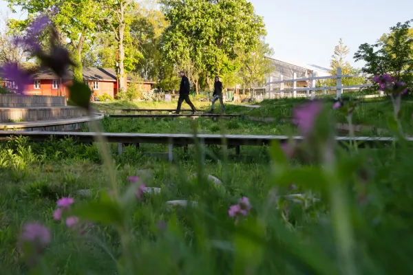
Detail of Karens Minde Park in Copenhagen by Claire Harbage, NPR.
Amsterdam vs Copenhagen: understanding the sponge city principle
Traditional urban development has long operated on the principle of rapid water removal, channeling stormwater through impermeable surfaces into gutters, pipes, and sewers to move it away from urban areas as quickly as possible. This approach, while effective at immediate flood management, creates a cascade of problems:
- overwhelmed drainage systems during heavy rainfall;
- reduced groundwater recharge;
- degraded water quality;
- urban heat islands;
- the loss of natural water cycles.
Sponge city construction sees urban environments as active participants in the hydrological cycle, where cities function like natural ecosystems. They do so by soaking up rainfall, filtering pollutants, storing water for dry periods, and gradually releasing excess water.
This approach operates through multiple integrated strategies. Green infrastructure replaces impermeable surfaces with permeable alternatives that allow urban water to infiltrate naturally.
Blue-green roofs act as water reservoirs, retaining water to be released slowly, supporting biodiversity and reducing urban heat. On top of this, constructed wetlands and bioswales¹ treat stormwater naturally while creating habitat corridors. They are in fact planted with native grasses, shrubs, and sometimes trees, and often include engineered soil mixes.
In this way, underground storage systems capture excess water for later use or controlled release. While, permeable pavements let water reach underlying soils and aquifers.
The benefits extend far beyond flood control. Sponge cities improve water quality through natural filtration, reduce urban heat island effects through evapotranspiration, enhance biodiversity by creating habitat networks, improve air quality, reduce energy consumption, and create more liveable urban environments. They also enable cities to build economic resilience by reducing infrastructure maintenance costs, creating green jobs, and increasing property values.
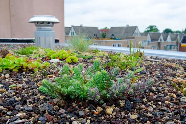
Amsterdam's blue-green roof by RESILIO.
Amsterdam, Netherlands: city-wide sustainable water management strategy
Amsterdam’s municipal programme transitioned from Rainproof (2014) to Weerproof (Weatherproof) in 2024, signalling a new stage of climate crisis resilience. Rather than building isolated tanks, the city empowers residents, businesses, and civic groups to create green roofs, permeable streets, gardens, and small parks that function like a sponge to absorb rainfall. By 2021, this collective network raised the city’s stormwater capacity from handling ~20 mm/hr to around 60 mm/hr.
Amsterdam’s green corridors are improving water infiltration, ecosystem connectivity, cooling cities, sequestering carbon, and enhancing air quality. What stands out in Amsterdam’s approach is how quay renovations, adaptive parks, and rain proof neighbourhood programmes converge. These spaces also become places for community interaction, exercise, and even local food production.
Amsterdam's blue‑green roofs
Unlike traditional green roofs, Amsterdam's 12.683m2 of blue‑green roofs, part of the RESILIO (Resilience nEtwork of Smart Innovative cLImate‑adaptive rOoftops) initiative, combine vegetation with water-storage layers and smart valves, turning rooftops into rainwater buffers.
These nature-based solutions (NbS) combine vegetation, smart valves and sensors, with water retention crates. In so doing, these roofs retain up to 70-97% of heavy rainfall (>20 mm/h), compared to 12-30% for conventional green roofs and 50% for non-smart blue‑green ones.
They form a connected digital network, sharing data in real time with Amsterdam Waternet, enabling dynamic city‑wide water load management. Notably, the blue-green roofs were installed across 4 neighbourhoods: Kattenburg, Indische Buurt, Oosterparkbuurt, and Slotermeer.
IJburg: a water-first neighbourhood against climate change
IJburg is a urban district created on 9 islands raised from Amsterdam’s IJmeer Lake, as compared to traditional polders which require continual pumping of water from the drained area. The IJsselmeer is a Natura 2000 area. Developed in 2 phases since 1999, IJburg will offer around 18,000 homes throughout 540 hectares once the project is complete.
Housing typologies include ground-level homes, and floating or amphibious dwellings. These floating homes are anchored on poles that accommodate water-level changes.
Rainwater falling on the islands is largely retained on-site, filtered through reed banks and discharged into the lake. This decentralised water management reduces strain on public sewer infrastructure and creates a landscape where water is both accessible and functional.
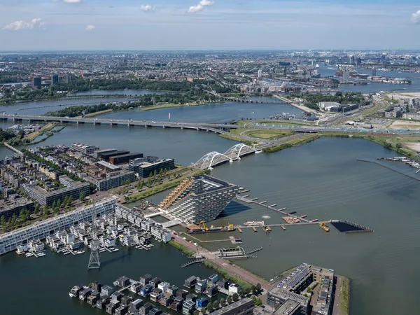
Aerial view of Ijburg and Sluishuis in Amsterdam by Ossip van Duivenbode.
Waterfront green areas & quay wall renovations
Terraces with planting beds on the city's canal network serve multiple integrated functions: absorbing excess rainwater, filtering pollutants, providing habitat for urban wildlife, and creating beautiful public spaces.
Amsterdam is also refurbishing hundreds of kilometres of quay walls and integrating resilient public realms. For instance, the SWSUD (Soil and Water Sensitive Urban Design) project in Tuindorp Oostzaan (TO), in Amsterdam North, proposes adding infiltration zones, and green spaces to Plejadenplein, a central square, and Meteorenweg, a central artery.
Copenhagen, Denmark: neighbourhoods mitigating floods
Following 2011 Copenhagen Climate Adaptation Plan, Copenhagen's strategy focuses on creating intensive, highly visible demonstrations of climate resilience at the neighbourhood scale.
After July 2, 2011, storm, the City of Copenhagen, jointly with the Ministry of Social Affairs, Housing and Senior Citizens, came up with the Cloudburst Management Plan (Skybrudsplan). The 2012 plan delineated 26 catchment areas for future interventions to be implemented over 2 decades. High flood risk will certainly be given priority.
The Klimakvarter, Østerbro: climate neutral neighbourhood
The Klimakvarter is identified as a demonstration area, integrating rain gardens, permeable streets, and community green spaces across Østerbro neighbourhood. In particular, Tåsinge Plads, Skt. Kjelds Plads & Bryggervangen reclaim underutilised space by removing asphalt and replacing it with rain gardens, bioswales, and permeable surfaces covering over 34,900 m².
Designed by Nature-Based Design Studio SLA, Third Nature Architects, NIRAS and HOFOR, this area showcases how climate infrastructure can serve community, ecology, and public health.
The Climate‑Resilient Block in Sankt Kjelds Quarter transforms a cluster of 13 residential backyards into a shared courtyard space, following a project by Henning Larsen architecture firm. Rainwater is treated as a resource, where rooftop runoff is captured for reuse in washing machines and courtyard water repurposed for toilet flushing. Excess stream from the 2 rain gardens flows into 2 retention basins, each holding up to 40 m³. The initiative has lowered water consumption by 27%.
Sydhavn to reduce flood exposure
Inaugurated in May 2023, the Karens Minde Axis (Karens Minde Aksen) features a 600-meter-long greenway which is capable of handling up to 15,000 m³ of cloudburst water. During heavy rains, the riverbed channels water into a trickle meadow, where sediment is naturally filtered before water flows into a newly created rainwater basin.
Karens Minde Axis in Copenaghen by Carsten Ingemann.
In dry conditions, the path remains seamlessly walkable, and underneath a circular wooden bridge sits a small rainwater lake and wildlife habitat. The project expands urban biodiversity and preserves approximately 70 mature trees.
Enghaveparken in Vesterbro: green spaces can also help
Across the city, 20 green areas are now transformed into “sponge parks” to relieve pressure on aging sewer systems. Originally designed in 1928 and restored by Tredje Natur, COWI, and Platant, Enghaveparken in Vesterbro neighbourhood holds an impressive 22,600 m³ of stormwater.
Historic tree avenues, Arne Jacobsen's grand tree avenues and pavilions remain intact, but have gained new functions. Moreover, collected stormwater is reused to irrigate plantings while fostering biodiversity through the introduction of 83 new trees, 11,000 perennials, 950 roses, and 220,000 flowering bulbs.
On the surface, 3 terraced sports courts and a sunken rose garden double as cloudburst reservoirs. During flash flooding events, water progressively floods the courts, garden, and reflecting pond in sequence. A perimeter dike with automatic flood gates engages without electricity, converting the entire park into a serene temporary lake, and once sewer systems regain capacity, the gates open and public access is restored.
Comparative analysis: Amsterdam vs Copenhagen
Amsterdam's sustainable urban design ensures that water management solutions work coherently across the entire metropolitan area. This creates efficiencies of scale and prevents the creation of isolated zones of resilience surrounded by vulnerable areas. However, this comprehensive approach requires enormous coordination across municipal departments and significant upfront investment across the entire city.
Copenhagen's pilot sponge neighbourhood-focused strategy allows for intensive intervention and community engagement within smaller areas, creating highly visible success stories that build political and public support for broader implementation. This approach enables rapid experimentation and iteration, allowing the city to refine approaches before scaling them up. However, it risks creating inequity between adapted and non-adapted neighbourhoods to flood mitigation.
¹ A bioswale is a type of green infrastructure designed to manage stormwater runoff through natural processes. From a physical perspective, it means a shallow, vegetated channel or depression As such, it proves to be a cost-effective alternative to traditional storm drains.